
Hikes on the Big Island: Exploring Nature’s Majesty on Foot
With so much land mass that all the other Hawaiian Islands can fit into the Big Island, there are a lot of open spaces and amazing landscape to explore all these Big Island hIkes. Many of the best hikes on the Big Island are relatively easy and covers flat or rolling terrain with fantastic views and landscapes that invite you to keep exploring. Check out all of these popular and some off the beaten path Big Island hikes and hopefully some of these hikes will make your to do list when you visit the Big Island soon. In my experience, these are the best hikes to do and enjoy around the island when you visit.
Also, you can bookmark this to share with friends or save for future hiking trips around Hawaii that will inspire you to be outdoors.

Best 23 hikes to explore on the Big Island
These Big Island hikes are broken up into different regions of the island to make it more accessible to where you are staying or want to explore at the moment.
Check out the BIg Island hikes on the west side, Kohala side, the south side of the Big Island, the east side of Hawaii and popular hiking areas around Hawaii Volcanoes National Park.

23 Fantastic Big Island hikes on the west side of Hawaii
The west side of the Big Island covers dry and arid coastal areas to more lush grassy terrain to mountain areas that inspire you to be outdoors. Check out all these fantastic hiking trails to discover on the west side of the island.
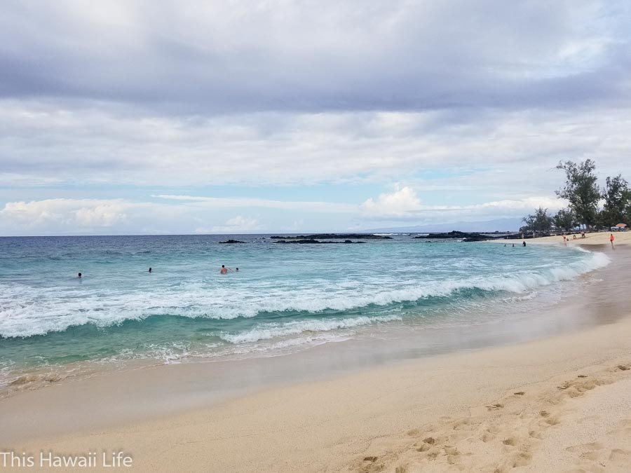
1. Makalawena Beach hike
After you take a rough gravel road from the main highway 19 between mile marker 22 and 23, you end up at Mahai’ula beach. The hike to Makalawena beach is about 20 minutes starting from the parking lot area through barren lava fields and skirting beautiful coastline and beaches and other rugged terrain. Eventually you reach the dunes area of Makalawena with a gorgeous expanse of beach area which is not crowded and a large crescent shaped beach all for you to explore. There’s also a shallow lagoon area to explore further down from Makalawena and fun to check out the many tropical fish that hang out in the sandy bottom lagoon area. Makalawena is definitely one of the best Big Island hikes to experience and enjoy along the coastline areas on the west side.
Distance – approximately 2.7 miles round trip
Difficulty – easy on graveled paths lava trail and dirt road
Here’s a quick look at the Makalawena beach hike below
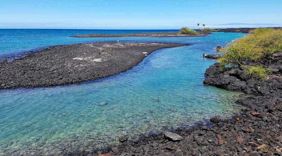
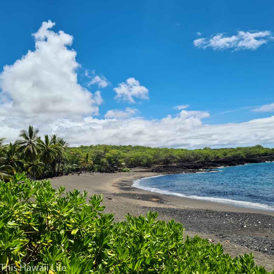
2. Kiholo Bay
One of the local Big Island hike to explore is at Kiholo Bay. The area around Kiholo Bay is where an ancient settlement was established with a large man-made fish pond. To get to the bay you have to enter from south of Mile Marker 81 on Highway 19 drive towards the ocean. At the road end, you hike up a trail leading to the north end of the fish pond and lava rock pahoehoe fields that end into the water. This stunning aqua blue water is striking against the stark black lava rock and makes it even more brilliant and clear to see all the sea life and tropical fish swimming around the bay and a wonderful hike to do for all hiking levels.
Distance – 5.5 miles round trip
Difficulty – moderate traffic on dirt and graveled road
Here’s a visit to Kiholo Bay below
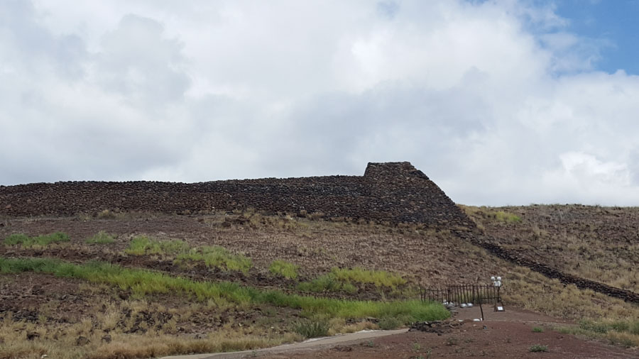
3. Pu’ukohola historic cultural trail
One of the easiest and best hikes on the BIg Island to do is at the Pu’ukohola historic cultural trail. This relatively short trail through the national monument is easy and on paved trails leading to key historic sites in the park. Specifically, the monumental heaui (temple) that the first king Kamehameha built to enact omens that he would be king if the temple was erected. Along the route you will pass through two other temples (one sunken in the bay to honor the shark god) and a beautiful crescent shaped beach in the end to hang out in. Check out their website here for more details to exploring this area.
Distance – .9 miles round trip to the monument and coastal return and back to welcome center
Difficulty – easy on paved route at the monument and then a graveled route through the coastline area.
Here’s a look at Pu’ukohola from above

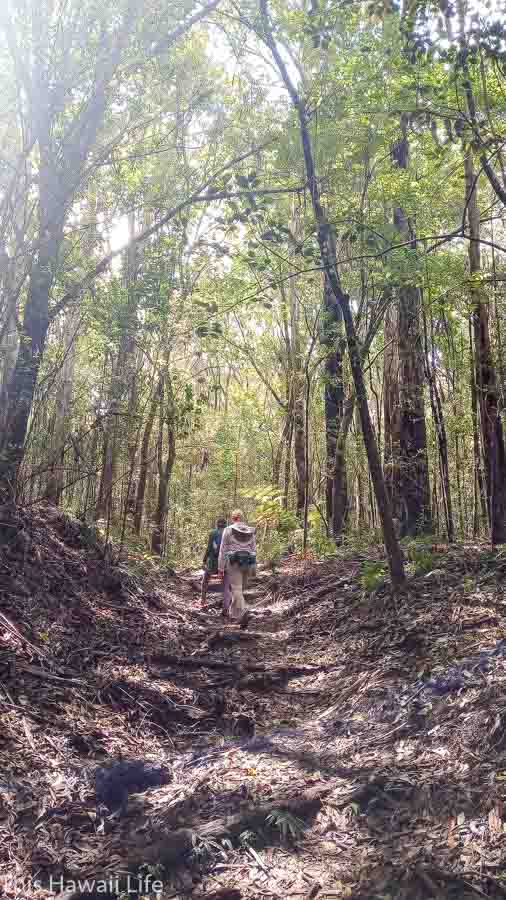
4. Pu’u Wa’a Wa’a
One of the most challenging Big Island hikes is to climb Pu’u Wa’a Wa’w. A green cinder cone that is located on the upper highway 190 outside of Kona, Pu’u Wa’a Wa’a is a fun and challenging hike to the top on mostly dirt and gravel road and eventually more dirt trail past lush cattle fields. From the top you get some lovely views of the Kona area all the way down to the coastline through Kona and up north through the Kohala coastline areas. The route is through a fire road that goes easily on an easy slope and then becomes a grassy trail midway. You can also detour on a more beautiful native tree forest on the Ohia trail that eventually connects back to the fire road to the mid section of the trail area.
Distance – 4 miles round trip and heavily trafficked
Difficulty – moderate on the steep road to the bottom and flat on the road to the actual monument
Here’s a visit to Pu’u Wa’a Wa’a with the hiking mom below

5. Captain Cook Monument
The hike down to the Captain Cook monument is both thrilling and challenging on the climb back up to the top. This challenging hike is easy from the top to the monument located at the bottom with fantastic snorkeling in the area. This historic monument is where Captain Cook was killed by local Hawaiians after it was realized that he was not the god/omen they had expected on the sacred period for the god Lono. The hike back uphill is a challenge and typically hot and dusty so make sure you have enough water on the way back to the top because the trail is exposed and sunny all day long.
Tip – try to do the hike early in the morning when the sun is not so harsh
Distance – 4 miles round trip and heavily trafficked
Difficulty – moderate on the steep road to the bottom and flat on the road to the actual monument
Check out the Captain Cook trail experience below
Top hikes on the Big Island’s Kohala and Hamakua coast
The western side around the Kohala to Hamakua coast is dramatic with rugged and lush terrain that makes exploring outdoors gorgeous and yet unpredictable and weather sensitive. Check out the popular hikes to explore below along the Kohala coastline to the Hamakua area of the island now.
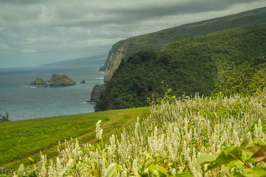
6. Polulu Valley hike
One of the prettiest Big Island hiking trails with gorgeous views is on the Polulu Valley hike. From the end point and parking lot you get a spectacular view of Polulu valley and the other gulches further out. But don’t stop there, you need to explore the amazing black sand beach below and hike the relatively short downhill trail to the base. From here you can follow some short trails up river or walk down to the black sand and rocky beach. If there are no strong currents, then a nice dip and day on the beach is a must.
If you’re interested in hiking to the top of the next valley at Honokane Nui at the top observation point, it is an additional mile uphill to the lookout area. You can also hike down to the base and rappel in a area with ropes towards the top of the downhill slope and hike through a stunning native palm grove, dry taro patches, ancient rock walls and villages towards the beach area.
Distance – .9 miles round trip and heavily trafficked
Difficulty – moderate on the steep road to the bottom and flat on the road to the beach area
Here’s a visit to Polulu Valley below

7. Waipio Valley hike
The Waipio valley hike is on the opposite end of Polulu valley with 7 gulches in between with a fantastic view on top from the lookout point. If you are up for a hiking challenge then walk down the 20% grade paved road on the left side which takes you to the valley floor. You can walk next to a meandering stream until it leads to the ocean. Along the way are wild horses that live in the area and roam around freely or looking for handouts. The ocean area is typically rough for swimming in, unless you get a nice calm day to enter the waters, or you can go closer to where the river enters in the ocean and take an easy dip there. Of course, the hike back uphill will be the real challenge and a cardio workout to get back to the top, so take your time and enjoy the views back uphill.
Distance – 3 miles round trip
Difficulty – moderate to challenging on the steep road to the bottom and flat on the road to the beach area
*** the valley is off limits to anyone while the road is being retrofitted so you can only see the valley from above on the observation trail currenty
8. Kalopa State Park
Located on the lush side of the Hamakua coastline, Kalopa State Park is a real gem. For those looking for wild, natural and old growth trees, you’ll find it here with giant native trees, shrubs cascading down into a gulch leading all the way to the ocean. There are a variety of trails that are easy to moderate covering all of the park in relatively easy walks and enjoying nature here. Kalopa State Park hikes range from 3/4 miles to more round loop trails around the park that are around 6 miles with other interconnecting trails leading the more popular gulch section and old growth trees in the park. With over 6 main trails, there’s plenty to choose from and you can even stay overnight in their cabins and enjoy the cool mountain air and quiet solitude here at Kalopa.
Distance – ranges from 3/4 mile to over 6 miles around the park area.
Difficulty – easy to moderate hikes through dirt and gravel paths
Here’s a quick look at Kalopa State Park below

9. Exploring Akaka Falls
The lush area of Akaka Falls on the Hamakua coast lies more inland where the cool temperature and moist conditions make the inspiring hike around the botanical gardens around Akaka Falls inspiring. You’ll come across large bamboo groves, huge tropical plantings of ginger, heliconia and other beautiful tropical plants. Along this paved path the is a loop, you’ll come across two large waterfalls at Akaka Falls and Kahuna falls and a variety of smaller waterfalls as you walk along the paved pathways.
Difficulty – easy paved pathway
Length – .4 mile loop
Akaka Falls loop is easy and short below
Top hikes to do on the Big Island’s southern side
The southern side of the BIg Island has inspiring hikes with Volcanoes National Park, the Kahuku unit of the park and many coastal hikes on the south side. You can explore some dramatic cliffside trails, balck and green sand beaches and some of the most unique landscape to explore on the south side of the island.

10. Kilauea Iki hike – at Volcanoes National Park
This popular hike in the national park takes you through the rim areas of the park cliffs with overlook to the new and deep canyon where the lava bed collapse to form high cliff areas surrounding the volcanic opening to Halema’uma’u where the volcano is quiet for the moment. The Kilauea iki hike takes you through lush areas opening to barren fields and fantastic views on the rim trails to the canyon below. The Kilauea iki hike is one of the most popular hiking trails in the park covering forested canopy, gorgeous views of the crater area and eventually to open lava fields below.
Distance – 3.3 miles round trip
Difficulty – moderate on forested paths to exposed lava field areas
Exploring the Kilauea Iki Trail below

11. Pu’u Loa – at Volcanoes National Park
One of the largest fields of pictographs located on the island, the Pu’u Loa hike and petroglyhs is very spiritual it was where women would take their newborn’s umbilical cords and bury them with a carved pictograph hole to symbolize the pico or center of the child’s new being and a rite for the child to have a strong and wholesome life growing up in the area. The hike is 1.4 miles round trip in relatively flat and rolling lava forms on exposed landscape. There is no water or public facilities on site so come prepared.
Distance – 1.4 miles round trip
Difficulty – easy on rolling lava pathways and boardwalk area
Check out the 26,000 petroglyphs at Pu’u Loa below

12. Kahuku Unit – Volcanoes National Park
Originally ranch lands in the upper hills above highway 11 past Na’alehu,the Kahuku Unit is operated by Volcanoes National Park with gorgeous landscape to hike through. With over six fantastic hikes to discover ranging from under .5 miles to over 5 miles with stunning views of the region, coastline and grassy meadows, rolling hills and jagged lava rock formations. You’ll enjoy this lush and cooler environment that is a different vibe and experience to the lower sections of the national park and surrounding landscape in the Kau region. First visit the welcome visitors center for maps and orientation of the area and some nice imagery and displays. You can also get some of the history and hiking information from knowledgeable staff and rangers before you begin your hikes.
Distance – ranges from .5 miles to 5 mile trails
Difficulty – easy to moderate hikes on rolling trails and graveled paths.
Check out the Kahuku Unit hiking trails below

13. Papakolea Green Sands Beach
This amazing hike to the one-of-a-kind green sand beach at Papakolea is easy and relatively flat. The trail from the parking lot follows the coastline most of the way to the beach which is a nice beach surrounded by small cliffs with stunning green sand made of olivine minerals which are created when fresh lava hits the ocean and develops into the mineral. You have to climb down a short series of stairs to get to the beach and if the waters are calm, it’s fantastic for swimming and snorkeling.
Distance – approximately 5 miles round trip
Difficulty – easy on beach gravel and sand
Here’s a visit to Pakaolea Green Sands Beach virtually below

14. Cliffside hikes from Ka Lae along the rugged coastline areas
From the South Point area of the Big Island at Ka Lae, the rugged cliffs that drop dramatically to the deep blue ocean is a colorful and picturesque hike to explore along the cliffs. Mostly flat and easy to follow trails or lava rocks the hike takes you past all the cliffs, hidden sea caves of the dramatic coastline that leads towards the taller cliffs with windfarms which is off limits to hike in that area of pastureland.
The weather is dry and windy so stay away from the edge with a sheer drop to the bottom and do protect yourself from the hot and dry heat in this explosed area.
Distance – approximately 1.5 miles round trip
Difficulty – easy on sand, dirt and lava rock

15. Punalu’u to Kamehame Beach
An off the beaten path, the hike to Kamehame beach goes through historic heaui, gorgeous coastal walks, the smooth rocks of the Ala Kahakai trail, lava rock fields with large cracks and then onto the gorgeous black and green sand beach at Kamehame beach which is a breeding ground for indigenous Hawksbill and green sea turtles or honu in the area and should be avoiced during breeding season from June to November. If you continue along the coastlines, you’ll also spot some stunning arches, coves and beautiful coastline to enjoy on this truly one of a kind hike on the south side of the island.
Distance – approximately 1.5 miles round trip
Difficulty – moderate on beach gravel and sand, lava fields and open coastal areas
Here’s a visit to Kaehame Beach below
16. Hike to Honomalino beach past Milolii
A very scenic hike on the coastline past the old Milolii village, the hike to Honomalino beach is varied with lush plantings of snake like cerious cactus plants, local trees and colorful lantana, you hike through coastal forest land, through sandy beaches, lava rock fields and jagged cliff side areas that are fascinating to walk through. Eventually you’ll spot a grove of coconut palms where the crescent shaped Honomolina beach stretches for a half mile and is fun to explore and swim if the weather and ocean is relatively calm to do into. You’ll enjoy this Big Island hike to Honomalino beach for the gorgeous scenery and varied terrain to experience along the way.
Distance – 1.5 miles roundtrip
Difficulty – easy on gravel, dirt and lava rock trail
Visiting Honomalino beach below

17. Nahuku Thurston Lava Tube
Located at Volcanoes National park, Nahuku Thurston Lava tube is a gorgeous and easy hike through lush forests of native Ohia and giant tree ferns and other indigenous plants until you reach the opening of the lava tube which is lit up and fascinating to explore. It is a little damp and wet inside, but the walkway is flat and relatively easy to do. A fast and wonderful experience with information displays sharing about the history, fauna and lava tube development in the park.
Distance – approximately 1.5 miles round trip
Difficulty – easy on graveled paths with a staircase leading down to the trail and relatively flat afterwards
Here’s a virtual visit to Thurston Lava tube below

18. Lava viewing at Devastation trail in Volcanoes National Park
The Devastation trail is popular for lava viewing day or night or just a gorgeous walk around the forested areas that open up to the caldera with views to the crater at Halema’uma’u. It is a beautiful and varied hike through open areas, meadows and forested old growth of native giant tree ferns and other flora in the park area. Visit any time of the day or maybe late afternoon to evening to get a view of the action in the caldera and live lava spewing across the crater floor. Parking area at the Devastation trail is very busy later parts of the day because of visitors looking to see the lava action at night so plan accordingly.
Distance – approximately1 miles round trip
Difficulty – easy on graveled paths with an elevation gain of 124 feet.
A visit to Devastation trail at Volcanoes National Park

Top hikes to do on the Big Islands East side
The east side of the island is lush with waterfalls, thick jungle and then varies to harsh lava fields with new black sand beaches to coastline areas to explore. Check out some of these inspiring hikes to visit on the east side on the lush side, striking coastlines and the mountain areas around the Saddle Road that will inspire you to be outdoors on the east side of the Big Island.
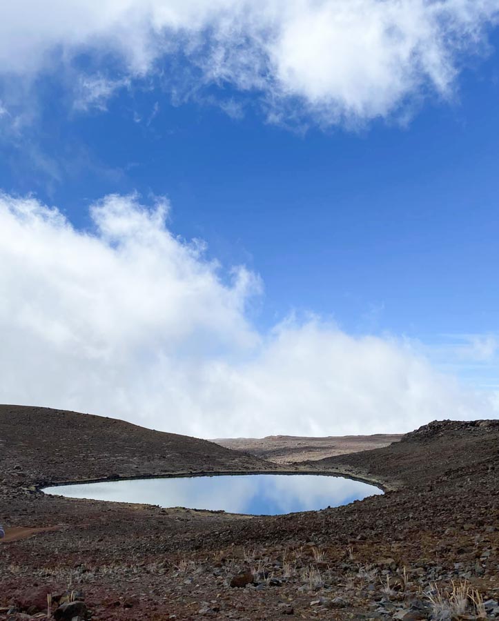
19. Lake Waiau Hike
At the top of Mauna Kea is one of the highest elevation lakes in the United States called Lake Waiau and located 2 miles below the trailhead at Mauna Kea summit. (At the moment access to the top of Mauna Kea is closed due to the protest on building the TMT telescope on top). A relatively short hike with great views but with the high elevation, you should take your time in the exposed area and high altitude. Go slow, drink water and enjoy all the fantastic views around the lake area.
Distance – approximately 1.4 miles round trip
Difficulty – Moderate hike on dirt and gravel

20. Hike to Narnia above Hilo
The relatively easy Narnia hike is mostly uphill climb through fire roads above the Boiling pots area off Wainuenue road ends at a spectacular viewing point with 5 waterfalls dropping to some wonderful pools. On non-rainy days the pools are relatively easy to enter and swim in and go right up to most of the waterfalls. Definitely a photo worthy place to visit to see a unique and off the beaten path hike above Hilo. The trail starts above Wainuenue past boiling pots (look out for parking off the road and before the bridge/waterfall area). Look for cars parking before the main bridge and take the fire road up mostly uphill until you see a large water tank and turn right to a forested area that opens up to fantastic views of the falls, spillways and waterfalls. Do not attempt to swim here on rainy days when the water is very rapid and unstable and also rangers come up regularly to give citations for going into state property.
Distance – approximately 3.7 miles round trip
Difficulty – easy on a fire road of dirt and gravel
Note – this is located on State property and tickets have been issued for swimming in the various water areas and not advised to do so.

21. Pu’u Cinder cone at Pu’u Huluhulu trail
Facing majestic Mauna kea and the entrance is the cinder cone which you can climb up to on the opposite side of the Mauna Kea road leading to the visitors center. Make a left at the Mauna Kea road intersection and enter through the parking lot and the trailhead is on the left side of the cone and all uphill on the dirt trail leading up to the top.
The trail is relatively fast with gorgeous views of wildflowers, native plants and views of the surrounding landscape. Pu’u Huluhulu is translated into hairy hill in Hawaiian and is an isolated kipuka of grassland and dense vegetation and rises up approximately 200 feet above the barren lava fields on the Saddle Road.
Distance – approximately 1.1 miles round trip
Difficulty – moderate uphill on mostly gravel and dirt trail road
Here’s a look at hiking upthe Pu’u Huluhulu trail

22. Kapoho hike to lighthouse road
The new Kapoho black sand beach in the Kapoho area off the lighthouse road still has no name but is a stunning beach to see with fine black sand crystals and flecks of green sand particles inside. Outside of the beach there are a few tide pool areas to visit and the historic lighthouse that withstood many lava intrusions into the area with cool graffiti painted on the walls of the base. The trail follows an old lighthouse road that is flat and partially covered with ironwood trees for shade but at the beach areas, the whole beach is open and exposed. One the left side towards the light house are several tidepools which are fun to explore and safely soak with excellent views.
Distance – approximately 1.5 miles round trip
Difficulty – easy on beach gravel and sand, lava fields and open coastal areas
The new black sand beach at Kapoho area
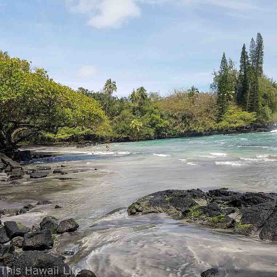
23. Ha’ena or Shipman beach hike in Hawaiian Paradise Park
To get to Ha’ena beach drive to end of Beach Road off Shower Road, you can park off the road and follow the dirt trail approx. five miles roundtrip to Shipman Beach which is a protected beach and lagoon that is a mixed black and white sandy beach. You’ll find a lot of green turtles, the endangered Hawaiian geese and tropical fish in the lagoon to snorkel around. The trail passes through lush jungle areas with coastline views of the area which are spectacular to take some small detour look out points. Finally reaching the beach and lagoon area with gorgeous black, white and green sand swirling around with the waves into beautiful patterns that are fun to watch.
Distance – 3.3 miles round trip
Difficulty – moderate on beach gravel and sand, lava fields and open coastal areas
A visit to Ka’ena or Shipman beach on the Puna District below
More details to hiking around the Big Island
Prepare and bring plenty of sunscreen, water and cover for hot exposed areas
Stay on the trails for your safety
Check out the trail heads information, kiosk or maps or any visitors center or rangers station
Remember to leave no trace behind and bring out everything you pack in.
Practise good hiking etiquette when your outdoors.
Bring food and water since there are no concessions and make sure to pack out your own trash.
Areas of the east and south side have unique indigenous trees that are being damaged by viruses, make sure to use the cleaning stations for your hiking shoes to prevent any viruses to attach to your shoes.
Weather and best time to visit the Big Island
The Big Island of Hawaii enjoys a diverse climate due to its varying landscapes and elevations. The weather on the Big Island can differ significantly depending on the region you are in. Here’s an overview of the weather patterns and the best time to visit:
Temperature: The Big Island experiences relatively consistent temperatures throughout the year. Coastal areas typically have average highs ranging from the mid-70s to the mid-80s Fahrenheit (mid-20s to low 30s Celsius). As you ascend in elevation, such as in the upland regions or Mauna Kea, temperatures become cooler.
Rainfall: The Big Island exhibits a range of microclimates, resulting in varying rainfall patterns. The eastern side of the island, including Hilo, tends to be wetter and receives more rainfall year-round. In contrast, the western side, including Kona, is drier and experiences less rainfall.
Best Time to Visit: The best time to visit the Big Island is during the dry season, which typically spans from April to October. This period offers more sunshine and fewer chances of rain, making it ideal for outdoor activities, beach visits, and exploring the island’s natural wonders. The summer months, particularly June to August, are popular among tourists and can be slightly busier.
However, it’s worth noting that the Big Island’s weather can be unpredictable, and brief showers can occur at any time. It’s a good idea to be prepared with rain gear and check the weather forecast before planning outdoor activities in the place you will be hiking at.
Additionally, the Big Island hosts various festivals and events throughout the year, providing additional reasons to visit. These include the Merrie Monarch Festival in Hilo (usually held in April), the Kona Coffee Cultural Festival in Kona (November), and the Ironman World Championship in Kailua-Kona (October).
Ultimately, the Big Island’s mild climate makes it a year-round destination, with each season offering its own unique experiences. Consider your preferred activities, crowds, and weather preferences when planning your visit to ensure an enjoyable stay on the Big Island of Hawaii.
Check out these other cool Big Island things to do
Black sand beachs on Hawaii Island
Best snorkeling spots around the Big Island
Must visit waterfalls around the Big Island
Free or cheap things to do around the Big Island
Did we miss any of cool or fun places to hike on the Big Island?
Please do share your favorites or any inside tips that can make a hiking experience here more enjoyable.

Conclusion to the top 23 hikes on the Big Island
Hiking the Big Island is filled with so much diverse terrain from coastline areas to cinder cones and lush valleys or cool mountain areas to explore on the island . The Best hikes on the Big Island are diverse and unique to explore. Each hike experience delivers big time depending on your interest in adventure activity is and challenge. Hopefully that you’ll get to experience the best hikes on the Big Island here and come back to explore regularly to see all of the island.

The road to the summit of Mauna Kea is not currently closed, but does require a 4WD, and the road can be closed for inclement weather (snow, blizzard conditions, road clearing).